Monday, July 18, 2016

7.4 Sense and Avoid Sensor Selection

            There are numerous small unmanned aerial systems (sUAS) available on the market for commercial applications to the average consumer.  Due to this there has been an increase in focus on developing a good sense and avoid sensor suite for sUAS applications.  Many are currently trying to develop better sense and avoidance technologies for sUAS.  The increase in commercial sUAS available to consumers has a created a need for an emphasis on safety to protect the public, national airspace, and infrastructure from sUAS accidents.  One company that has developed a system to help with this is DJI.  The system has several key features that make it an advanced sense and avoid system.  DJI has created the Guidance visual sensing system that has five sensor modules and one central processor, that integrates visual cameras, ultrasonic sensors and advanced computer vision algorithms (DJI, 2016c).  These sensors allow for it to perform several key functions for obstacle sensing and avoidance, along with precision accuracy when hovering.  The system continously scans the environment and detects obstacles in real time, and when used with a DJI flight controller it can tell the system to avoid collisions at high speeds (DJI, 2016c).  Along with this it also allows for the system to have precision positioning capabilities without the GPS.  When flying at high speeds high, stereo algorithms allow for positioning information over most terrains, and the system is effective at altitudes of up to 65 feet, which allows for hovering that is accurate to within centimeters (DJI, 2016c).  Figure 1 shows the hardware and sensors that come in the Guidance package.
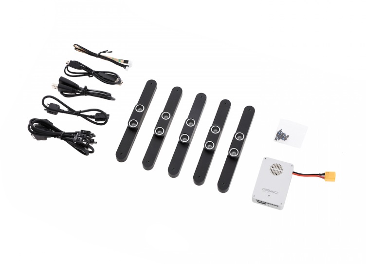
Figure 1: (Source: DJI, 2016a)                

The Guidance system can be used on several DJI sUAS.  According to DJI (2016a), Guidance has the following specifications:   
  • Core dimensions of 78.5 mm x 53.5 mm x 14 mm, with a weight of 64 grams.
  • Sensor dimensions of 170 mm x 20 mm x 16.2 mm, with a weight of 43 grams per sensor.
  • A 200 mm VBUS Cable, with a weight of 11.6 grams.  
  • An effective sensor range of .20 m to approximately 20 meters, and must have good lighting with texture-rich surface and clear patterns.
  • A velocity detection range of 0 to approximately 16 m/s, 2 m from the ground.
  • A velocity detection accuracy of .04 m/s, 2 m from the ground.
  • A positioning accuracy of .05 m, 2 m from the ground.
  • A power consumption of 12 W with all five sensors, and an input voltage of 11.1 volts to approximately 25 volts.
  •  An operating temperature range of -10o Celsius to approximately 40o Celsius.
  • Is supplied with five VBUS cables and has UART level of 3.3. 
Of the items mentioned above, the following items are included in the Guidance box; one Guidance core, five Guidance sensors, five standard VBUS cables, one long spare VBUS cable, one CAN-Bus cable, one micro-USB cable, one micro-USB cable extender, one UART cable, and a package of 25 M2x5 screws (DJI, 2016b).  The technology incorporated into the DJI Guidance systems makes it a very capable sUAS sense and avoidance system. 
            If I were to have any recommendations it would be to improve it to be effective above 65 meters and to be able to be used with all sUAS flight controllers for systems under 55 pounds.  As previously mentioned the Guidance system can be used with several DJI sUAS.  The following video demonstrates the use of the Guidance system on a DJI Matrice (Drone Scan, 2015). Video link: https://www.youtube.com/watch?v=V94zsX3wh_I

The cost of the Guidance system is $999.00, with free shipping, through the DJI website (DJI, 2016b).

References:


DJI. (2016c). Guidance: A revolutionary visual sensing system for aerial platforms. Retrieved July 18, 2016, from DJI: http://www.dji.com/product/guidance

Drone Scan. (2015, August 21). dji guidance optic flow testing in warehouse. Drone Scan. Retrieved from https://www.youtube.com/watch?v=V94zsX3wh_I

Sunday, July 10, 2016

Control Station Analysis for an Unmanned Ground Vehicle

Activity 6-4 Research Assignment: Control Station Analysis
Technology is continuing to evolve and advance for unmanned systems.  Unmanned systems continue to increase the amount of data they can provide from their sensors.  Due to the advancement in technology for these systems it is important for the operator to invest in a reliable and universal control station.  It is advantageous for the end user to have a control station that can operate unmanned systems from several platforms, such as both unmanned aerial systems (UAS) and unmanned ground vehicles (UGV).  In researching products for UGV control stations that have this capability UAV Factory’s commercial-off the shelf (COTS) dual display mobile station (DDMS) fits this description.  It can control a multitude of unmanned vehicles, including UAS, UGV, remotely operated vehicles (ROV), and bomb disposal robots  (UAV Factory, 2016).  It is important to the end user that this system is capable of operating both aerial and ground vehicles, for cost savings, so an end user does not have to purchase a separate system later if they were to need one for operating a UAS.
UAV Factory’s COTS DDMS is a rugged system that has a multitude of features for UGV operations.  According to UAV Factory (2016), the hardware specifications include the following:
  •        Its dimensions are 1000 x 420 x 170 mm, with a weight of 18.9 kg.
  •          An operating temperature of -20o to 60o Celsius.
  •          Electronics compartment dimensions of 320 x 270 x 80 mm.
  •          A M4 threaded mounting grid, with a 45 mm pitch and an aluminum mounting kit for the electronics mounting base.
  •          An included accessory bag with the dimensions of 220 x 160 x 70 mm.
  •          A rugged plastic case with side and carry handles, wheels, pressure purge valve, and an optional shoulder strap.
  •          A computer docking station for mounting a computer.
  •          A 17 inch TFT 1280x1024 (SXGA) display that has a brightness of 1600 nits and an       optional VGA input, with an optional touch screen.

The control station has an impressive power distribution system, too.  It includes two 108 Wh hot-swappable lithium-ion batteries with a two hour battery life; can be powered by 10 to 32 volts of direct current with over-voltage and reverse polarity protection; two 50 Ohm antennas; and provides two 12 volts of direct current, 50 W power outputs for the electronics compartment and external devices (UAV Factory, 2016).  Last according to UAV Factory (2016), there are the following ports for connection to the computer:
  •          2 serial RS-232
  •          5 USB
  •          2 Ethernet
  •          1 Composite Video in
  •          1 optional VGA
  •          1 microphone in
  •          1 audio out
  •          PCMCIA slot
  •          1 HDMI

As seen by the power distribution listed above and the connections available to the computer, the control station has a very sophisticated and advanced power distribution system. 

The ground control station has a lot of features available for UGV control operations and not many changes are needed to the system.  One disadvantage to the system is an end user must purchase a Panasonic Toughbook CF-31 to operate the control station, and it is currently the only computer that is compatible with the control station (UAV Factory, 2016).  According to UAV Factory (2016), the COTS DDMS must be used with a Panasonic Toughbook CF-31 that has the following specifications:
  •          A 13.1 inch XGA touch screen LED 1024x768 display.
  •          Durability of MIL-STD-810G & IP65 certified (6' drop).
  •          A brightness of 1100 nits.
One recommendation I would have is for control station to be compatible with other computers besides the Panasonic Toughbook CF-31, or for it to come with its own compatible computer with data analyzing and tracking software.  It appears to the end user that they must purchase and download their own software, to the Panasonic Toughbook, for tracking flight operations and collecting data.  This could allow for even more cost savings for the end user, which in turn may also increase sales of the control station if it is compatible with more computers that end users may already be using.

References:
UAV Factory. (2016). Portable Ground Control Station. Retrieved July 10, 2016, from UAV Factory: http://www.uavfactory.com/product/16

Sunday, June 26, 2016

Unmanned System Data Protocol and Format - DJI Phantom 4

4.5 - Research Assignment: Unmanned System Data Protocol and Format

There are many commercial unmanned aerial systems (UAS) on the market that currently incorporate a multitude of sensors that require data systems, protocols, and storage methods to make them an effective and functional system.  One system currently on the market that incorporates this technology is the DJI Phantom 4 (P4).  The P4 officially went on sale March 15, 2016 (Martin, 2016).  The P4 has an impressive sensor suite that allows for it to handle a multitude of functions.  According to Jim Martin (2016), the P4 has the following capabilities based on the sensors on board:
  •          An Obstacle Sensing System that uses ultrasonic sensors plus two front facing and two downward facing cameras allowing it to see and avoid people, buildings, or other obstacles.
  •          An Active Track function that lets the system track a moving subject without GPS navigation.
  •          A TapFly function that allows the user to fly the system with a smartphone by tapping where the user wants it to go, in a well-lighted environment, allowing the avoidance technology to handle the flight path.
  •          A vision positioning system with an effective range of up to 10 meters.
  •          A 4K camera that is attached to a gimbal that can record slow motion video capture of 120 frames per second at 1080 pixels.
  •          An intelligent flight battery with a capacity of 5350mAh, and a flight time of 28 minutes.

The P4 allows the data collected by the sensors to be stored in several ways.  One way data can be collected and stored is by an onboard micro SD card, with a max capacity of 64 gigabytes (DJI, 2016b).  DJI has developed the DJI GO app for Apple iOS and Android devices that uses a real-time HD downlink to see what the camera sees (DJI, 2016a).  According to DJI (2016a), the following data from sensors can be downloaded the DJI GO app:
  •          The aircraft’s position and heading.
  •          Images and videos.
  •          Fight log data through the Flight Record feature.

The DJI GO app has the following specifications:
  •          Equivalent isotropically radiated power (EIRP) of 100mW
  •          Power Spectral Density of 6.9mW/MHz and a live view working frequency of 2.4GHz ISM
  •          A live view quality of 720p at 30 frames per second with a latency of 220ms, depending on the conditions and mobile device.
  •         Required operating systems of iOS 8.0 or later and Android 4.1.2 or later (DJI, 2016b).

As mentioned previously the P4 is equipped with an obstacle sensing system, vision positioning system, and a 4K camera.  The Obstacle Sensing System has a sensory range of 2 to 49 feet and must have a surface with a clear pattern and adequate lighting of greater than 15 lux, for its operating environment (DJI, 2016b).  The vision positioning system has an altitude and operating range of 0 to 33 feet, along with the same lighting requirements as the Obstacle Sensing System (DJI, 2016b).  According to DJI (2016b), the 4K camera specifications are:
  •          12 megapixels, attached to a gimbal with a 3-axis stabilization and pitch of -90o to +30o.
  •          A lens with an operating field of view (FOV) of 94o 20mm.
  •          An ISO range of 100 to 3200 for video and 100 to 1600 for photos.
  •          A shutter speed of 8s to 1/8000s with a maximum image size of 4000x3000 pixels.
  •         A max video bitrate of 60 Mbps
  •         JPEG and DNG photo files and MP4 and MOV (MPEG-4 AVC/H.264) movie files.
  •          An operating temperature range of 32 to 104 degrees Fahrenheit.

In order to power the P4 it is incorporated with an intelligent flight battery system.  The intelligent flight battery weighs 462 grams; is a LiPo 4S battery with 15.2 volts; has energy of 81.3Wh; and has a maximum charging power of 100W with an operating temperature of 14 to 104 degrees Fahrenheit (DJI, 2016b).  
The P4 also has several other sensors that are built into the airframe to assist in flight operations.  In order to assist the global positioning system (GPS) the P4 has dual inertial measurement units (IMUs) and dual compass modules.  The data these sensors receive is run through algorithms to check for accuracy, any inaccurate data is then discarded without affecting the flight of the system (DJI, 2016c)
The P4 is controlled by the DJI Phantom 4 remote control.  It has an operating frequency of 2.400 GHz to 2.483 GHz with an operating voltage of 7.4 volts at 1.2 amps; a maximum transmission distance of 3.1 miles; can operate in temperatures from 32o to 104o Fahrenheit with a 6000mAh LiPo 2S battery; and has a FCC transmitter EIRP of 23 dBm (DJI, 2016b).  Last, according to DJI (2016b), the P4 has the following specifications:
·         Weighs 1380 grams with a maximum speed of 20 meters per second.
  •          An ascent speed of 6 meters per second with a descent speed of 4 meters per second.
  •          Can operate at a maximum of 19,685 feet or 6,000 meters above sea level.

  •          Has a vertical and horizontal hover accuracy of +/- .1 meters and +/- .3 meters respectively when vision positioning is active.

            The DJI Phantom 4 is an excellent commercial UAS for an end user who wants to use it for aerial videography and photography.  There are a couple of changes I would make to the system.  First, it appears that the camera cannot be switched out with the gimbal it is attached to.  I would make it so it can be used with several different brands of cameras, such as GoPro and Sony, and other thermal infrared, multispectral, and hyperspectral sensors.  I think it would be good for DJI to also find another means of data storage for the Phantom 4.  I think this would be an important feature to consider incase the micro SD card becomes damaged during flight, and if the DJI GO app becomes inoperable during an operation.  DJI might consider adding cloud storage solutions for data after flight operations, too.  DJI could try to incorporate other solid state drives (SSD) into the system for storage solutions, such as the Microsemi Corporation’s low power mSATA SSD that has 64GB single-level cell (SLC) flash capacity in a 50mm x 30mm compact size, designed for unmanned aerial vehicles (Unmanned Systems Technology, 2015).
References:
DJI. (2016a). DJI GO - Capture and Share Beautiful Content Using this New App. Retrieved June 26, 2016, from DJI: http://www.dji.com/product/goapp

DJI. (2016b). DJI Phantom 4 - Spec, FAQ, Tutorials and Downloads. Retrieved June 26, 2016, from DJI: http://www.dji.com/product/phantom-4/info#specs

DJI. (2016c). Phantom 4 - DJI's smartest flying camera ever. Retrieved June 26, 2016, from DJI: http://www.dji.com/product/phantom-4

Martin, J. (2016, April 20). DJI Phantom 4 release date, price, specs: the drone that can fly itself and avoid obstacles. Retrieved June 26, 2016, from PC Advisor: http://www.pcadvisor.co.uk/new-product/gadget/dji-phantom-4-release-date-price-specs-3636067/

Unmanned Systems Technology. (2015, August 13). Microsemi Introduces Secure Solid State Drive for High-Security Embedded Applications. Retrieved June 26, 2016, from Unmanned Systems Technology: http://www.unmannedsystemstechnology.com/2015/08/microsemi-introduces-secure-solid-state-drive-for-high-security-embedded-applications/

Monday, June 20, 2016

UAS Sensors related to an aerial photgraphy UAS and an FPV Racer


3.4 Research Assignment: UAS Sensor Placement
Recently aerial photography, from high definition videos to still photos, has become a big point of focus in the commercial UAS industry.  There are numerous UAS on the market that seem to be capable of these tasks, as this industry continues to grow.  One UAS that is very capable of performing these tasks and has a lot of options for the end users is the 3DR Solo.  3DR has designed and developed an UAS that has many functions and will be able to adapt to the evolving enhancements to the product.  According to 3DR (2016) the Solo has the following functions:
  • ·       An orbit function that allows for GoPro camera to lock on to any object with the push of a button, allowing it to fly around in a circle keeping the camera focused on the subject.
  • ·       A follow mode that allows the user to go completely hands free and focus on the user at all times, and it has the ability to enter “free look” mode to let the user take control of the camera.
  • ·       A cable cam mode that acts as a virtual cable to keep it on a track to set unlimited key frames at any points in the air, which allows the user to pan and tilt the camera without piloting.
  • ·       A selfie mode that allows recording clips directly to a user’s smartphone for saving and sharing.
  • ·       A pano mode that allows for capturing an aerial panorama, allowing the Solo to automatically pan and snap photos.
In addition to the above functions 3DR has designed the Solo to adapt to future enhancements to the UAS.  Future enhancements include an accessory bay with a ballistic parachute system for safety in the event of system failure, wireless updates, swappable motor pods, LED lights and an optical flow sensor, which most of these attach to the bottom of the frame of 3DR Solo (3DR, 2016a).  Along with this the 3DR Solo can record live HD video and 12 megapixel photos from a GoPro camera attached to a gimbal on bottom of the frame, satellite view for location accuracy, one touch shot control, real-time safety information, and user-defined geofencing through the 3DR Solo iOS and Android App (3DR, 2016c).
Due the safety functions incorporated into the 3DR Solo, multiple video and photo recording modes, and evolving adaptability the 3DR Solo offers for the end user, I have chosen it as a UAS platform to record HD video and still photos below 400 feet.
In addition to aerial photography applications increasing lately in the UAS industry, FPV racing has grown exponentially worldwide.  Due to this there have been many commercial FPV racing UAS that have entered the market recently.  In not being very familiar with racing drones I researched top racing drones on the market.  In conducting my research one FPV racing UAS that I came across is the Vortex 250 Pro by Immersion RC.  It has been recommended through a drone buying guide as the top expert FPV racing drone (Nixon, 2016).  The Vortex 250 Pro seems to be a top of the line 250 size FPV racer due to sensors and other items that it comes with, and therefore I would chose this as an FPV racing UAS.  According to Immersion RC (2016) it includes the following items:
  • ·       An approximate weight of 415 grams with no battery or HD camera
  • ·       A power requirement of 3s-4s LiPo battery
  • ·       State of the art F3 flight controller processor
  • ·       2nd Generation 20 Amp Ez electronic speed control, with custom 2204-2300kV motors
  • ·       Built in 2 megabyte black box recorder
  • ·       Carbon fiber frame
  • ·       An Integrated 40 channel NexWaveRF 5.8GHz video transmitter
  • ·       Tiltable, vibration-free camera mount
  • ·       Includes a GoPro ¾ camera mount
There is one downfall to this FPV racer in that a few extra items need to be purchased initially.  A compatible receiver and display device must be purchased separately for operating and setting up the vehicle (Immersion RC, 2016). 
The above mentioned 3DR Solo and the Vortex 250 Pro are two UAS that are very capable of carrying out the intended tasks for the end user.  The 3DR Solo camera placement on the bottom of the frame allows for it to capture HD video and still images an end user would need.  In addition to this the accessory bay allows for flexibility and adaption to the systems for future applications.  The front positions of the cameras and the tiltable mounts on the Vortex 250 allow for it to be a very high performance racer, along with the placement of the flight control board within the carbon fiber frame (Immersion RC, 2016).  I would recommend these two UAS to an end user to accomplish their goals. 
References:
3DR. (2016a). Built to Evolve 3DR Drone & UAV Technology. Retrieved June 19, 2016, from 3DR: https://3dr.com/evolve/
3DR. (2016b). Smart Shots 3DR Drone & UAV Technology. Retrieved June 19, 2016, from 3DR: https://3dr.com/smart-shots/
3DR. (2016c). Solo Smart Drone 3DR Drone & UAV Technology. Retrieved June 19, 2016, from 3DR: https://3dr.com/solo-drone/
Immersion RC. (2016). Vortex 250 Pro. Retrieved June 20, 2016, from Immersion RC: http://www.immersionrc.com/fpv-products/vortex-250-pro/
Nixon, A. (2016, May 1). Racing Drone Buyers Guide. Retrieved June 20, 2016, from Best Drone for The Job: http://bestdroneforthejob.com/drones-for-fun/racing-drone-buyers-guide-2/